
The case studies below show how MMA applies numerical groundwater modeling, field-data analysis, and expert testimony to water-supply, planning, and permitting questions for utilities, regional agencies, consultants, and legal teams.
Integrated groundwater and surface water modeling.
Groundwater model review and expert testimony.
Groundwater modeling for a proposed aquaculture facility.
Transient groundwater modeling for a new water supply well.
Groundwater condition review for a proposed residential development.
Client
Southeastern Regional Planning & Economic Development District (SRPEDD)
Location
Southeastern Massachusetts
Focus
Linked MODFLOW 6 regional and subregional models
Assawompsett Pond Complex and Mattapoisett River Corridor
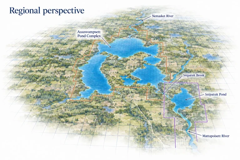
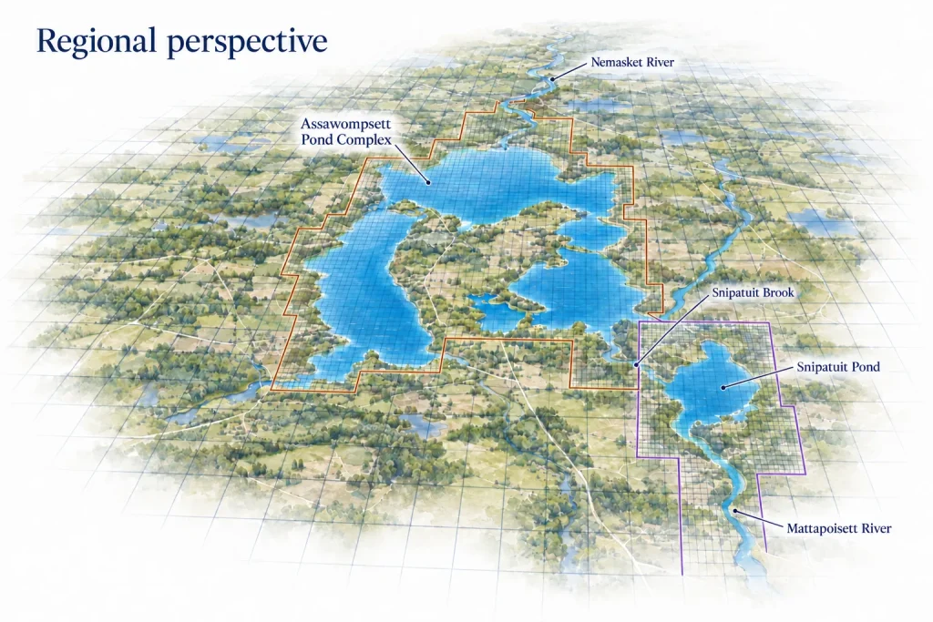
McDonald Morrissey Associates (MMA) developed and refined a linked MODFLOW 6 modeling framework to help stakeholders, including water suppliers and regional planners, evaluate how groundwater withdrawals and recharge conditions affect interconnected ponds, rivers, and aquifers. The work provides a consistent foundation for comparing water-management alternatives across the Assawompsett Pond Complex, Nemasket River, Snipatuit Pond, and Mattapoisett River corridor.
Water-resource decisions in these watersheds require an understanding of both regional groundwater flow and local exchanges with surface water. Pond levels influence river outflows and inter-pond exchanges, while groundwater sustains streamflow and contributes seepage to the ponds. Along low-gradient Snipatuit Brook, small differences in pond stages and channel elevations can determine whether water flows between ponds and in which direction.
Connect regional and local conditions. MMA linked a regional model with two refined subregional models using MODFLOW 6 groundwater-flow exchanges. The models solve groundwater conditions together, preserving water balance across shared boundaries while providing 100-foot grid resolution in the focal watersheds.
Represent pond and stream interactions. We incorporated pond bathymetry and the MODFLOW 6 Lake Package to calculate pond stages and estimate storage volumes, inflows, and outflows. Linked surface-water features allow the framework to represent connections among ponds and receiving rivers.
Adapt to complex flow conditions. For Snipatuit Brook, we developed an approach that accommodates disconnected ponds or pond-to-pond flow in either direction. Available field observations informed the representative condition evaluated in the updated model.
Evaluate model consistency. We compared simulated groundwater levels at 632 existing calibration target locations and reviewed simulated baseflows against available streamflow records. The updates retained groundwater-level agreement comparable to the preceding model.
The resulting steady-state framework supports regional, planning-level comparisons of withdrawal and recharge scenarios and their effects on groundwater conditions, pond stages, and streamflow. Its modular design provides a practical starting point for focused watershed studies and future transient modeling. MMA also identified targeted data collection and refinements to strengthen subsequent predictive analyses as management questions become more specific.
Client
Hill Law on behalf of neighboring property owners and petitioners
Location
Weston, Massachusetts
Documented involvement
2020–2025
Hanover Weston Residential Development | Weston, Massachusetts
McDonald Morrissey Associates (MMA) provided independent hydrogeologic review and expert testimony concerning proposed stormwater and wastewater infiltration at the Hanover Weston residential development. Across successive design revisions, local reviews, and state permit appeals, MMA examined whether the applicant’s groundwater modeling reliably represented site conditions and potential effects on neighboring properties and wetlands.
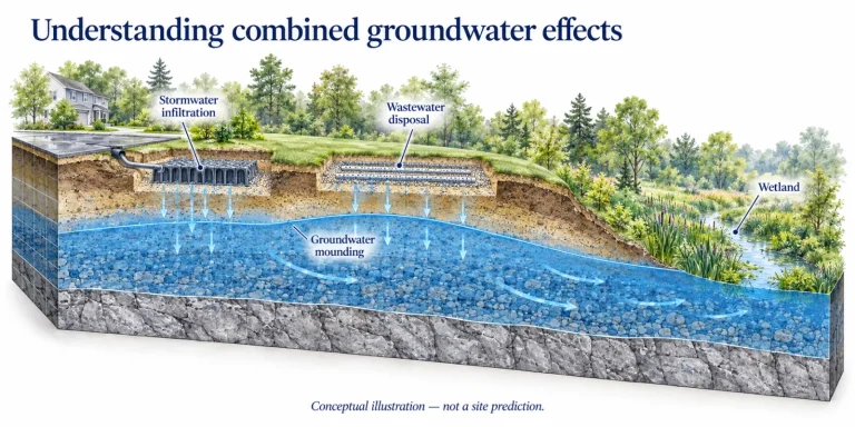
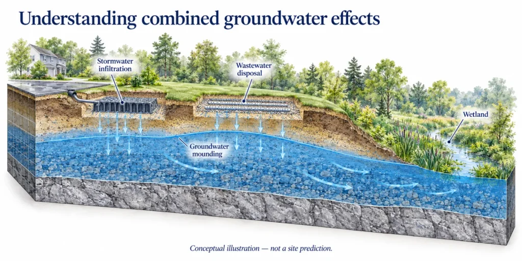
The proposal concentrated stormwater recharge and treated wastewater disposal near a bordering vegetated wetland. Evaluating the combined effects required consistent treatment of infiltration volumes, seasonal high groundwater, and groundwater mounding. A central question was whether rising groundwater could reduce infiltration capacity and undermine assumptions used in the stormwater design.
2020 | Initial independent review. MMA reviewed hydrogeologic data and the applicant’s MODFLOW input and output files, evaluated model construction and calibration, and performed diagnostic simulations. The review identified concerns about groundwater-flow representation, infiltration loading, and consistency with the stormwater analysis.
2021–2023 | Review through design revisions. MMA assessed successive models and revised infiltration layouts, submitted technical comments to local reviewers and MassDEP, and examined responses to agency deficiency letters. The work addressed seasonal high groundwater, model boundary conditions, and the relationship between HydroCAD infiltration estimates and MODFLOW mounding predictions.
2024 | Wetlands and discharge permit review. MMA prepared a February technical memorandum supporting review of the Notice of Intent and November comments addressing the draft groundwater discharge permit and wetlands issues. Diagnostic runs using the applicant’s available model files isolated wastewater-related mounding near the wetland boundary.
2025 | Expert testimony and rebuttal. Michael Mobile, Ph.D., CGWP, submitted pre-filed testimony and rebuttal in the wetlands appeal in March and June, followed by groundwater discharge permit appeal testimony in July and October. Supporting work included comparisons of pre- and post-development scenarios and calculations testing porous-pavement infiltration volumes.
MMA translated a complex, evolving modeling record into specific technical issues supported by calculations, model-file review, and explanatory exhibits. This work gave counsel and petitioners a documented basis for questioning modeling assumptions, evaluating potential groundwater impacts, and presenting technical evidence through multiple review and appeal stages.
Project history reflects the supplied record through October 2025; no final appeal disposition is represented.
Client
Ransom Consulting, Inc. and Nordic Aquafarms
Location
Belfast, Maine
Documented involvement
2018–2020
Nordic Aquafarms | Belfast, Maine
McDonald Morrissey Associates (MMA) developed and applied a site-specific numerical groundwater model to evaluate potential water-supply well configurations for the proposed Nordic Aquafarms facility in Belfast. The assessment examined recharge sources, pumping-related drawdown near neighboring wells, and the long-term response of the local fractured-bedrock aquifer.
The proposed facility required a reliable groundwater supply while protecting existing private wells. The site’s water resources are connected: pumping can change groundwater levels and alter discharge to streams, reservoirs, and the coastal boundary. A useful assessment needed to represent the local geology, surface-water connections, coastal tides, and measured aquifer responses during pumping.
MMA built a three-dimensional MODFLOW-USG model from geologic, topographic, well, streamflow, groundwater-level, and tidal information. Its flexible unstructured grid concentrated resolution around supply wells and key boundaries, refining to approximately 9-inch cells near wells and expanding to roughly 800-foot cells near the model perimeter. Three model layers represented overburden, weathered bedrock, and the productive fractured-bedrock aquifer.
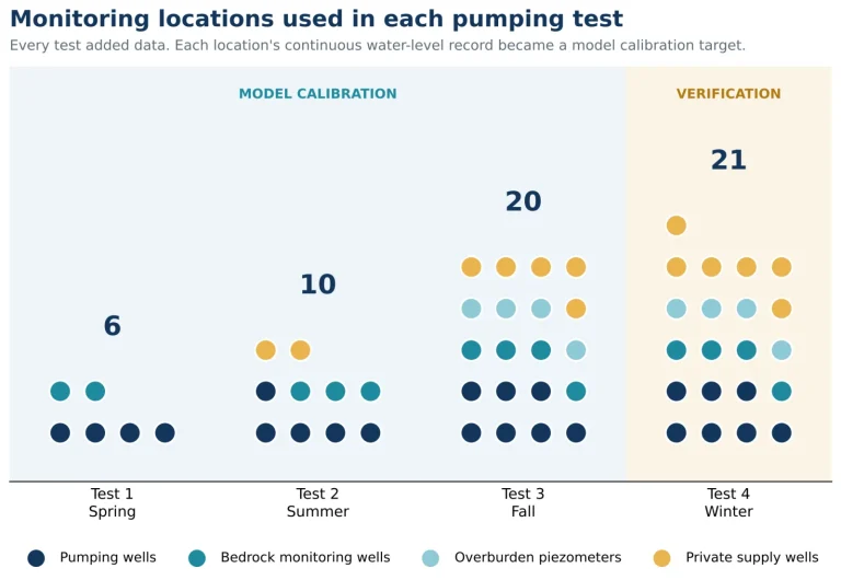
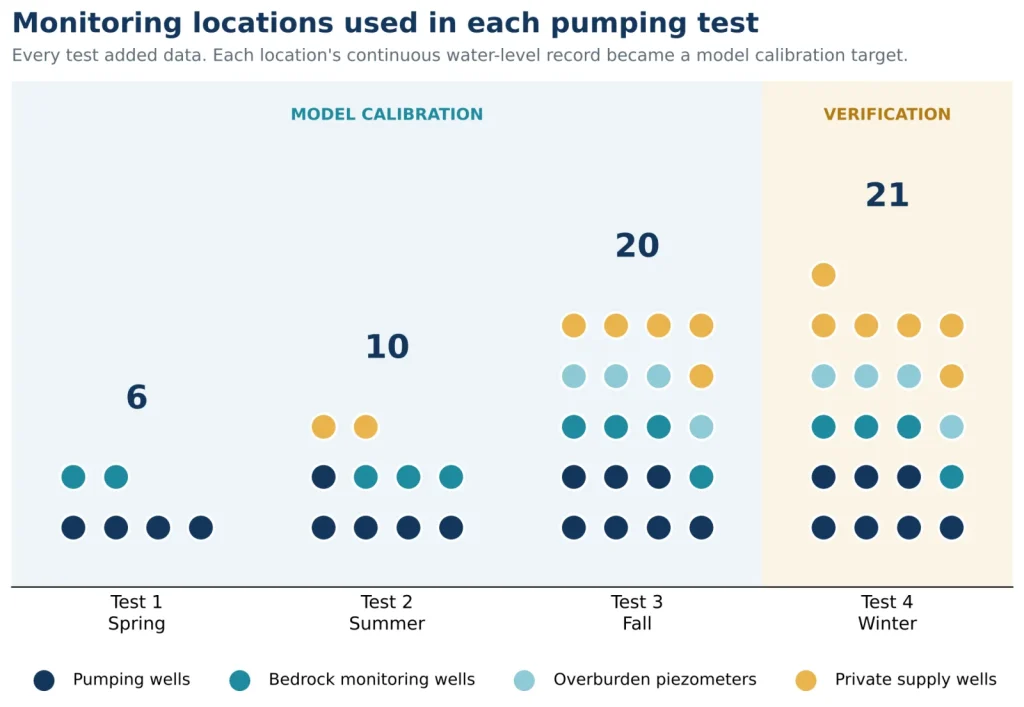
MMA calibrated the model to observations from three aquifer tests and checked it against a fourth independent test. The model represented streams, reservoirs, and tidal coastal conditions, then compared three pumping configurations under estimated average recharge and reduced-recharge conditions. Steady-state simulations estimated stabilized drawdown; transient runs estimated how quickly effects could develop.
The analysis supported further consideration of a 455-gallon-per-minute configuration using three wells and showed how alternative pumping rates could change simulated drawdown. For that scenario, estimated drawdown at a monitored off-site bedrock well was about 15 feet under average recharge and exceeded 20 feet at some off-site wells under reduced recharge. Transient results indicated that responses could take many years to more than a decade to stabilize.
MMA recommended establishing baseline conditions, monitoring on- and off-site bedrock wells and shallow groundwater near surface-water features, and preparing contingencies if pumping affects existing supplies. The model provided a quantitative planning basis while recognizing uncertainty in representing fractured bedrock as an equivalent porous medium and in projecting long-term recharge conditions.
Client
Wright-Pierce / North Kingstown Water District
Location
North Kingstown, Rhode Island
Project focus
Assessing Well 3R as a replacement for Wells 3, 7, and 8
North Kingstown Water District | North Kingstown, Rhode Island
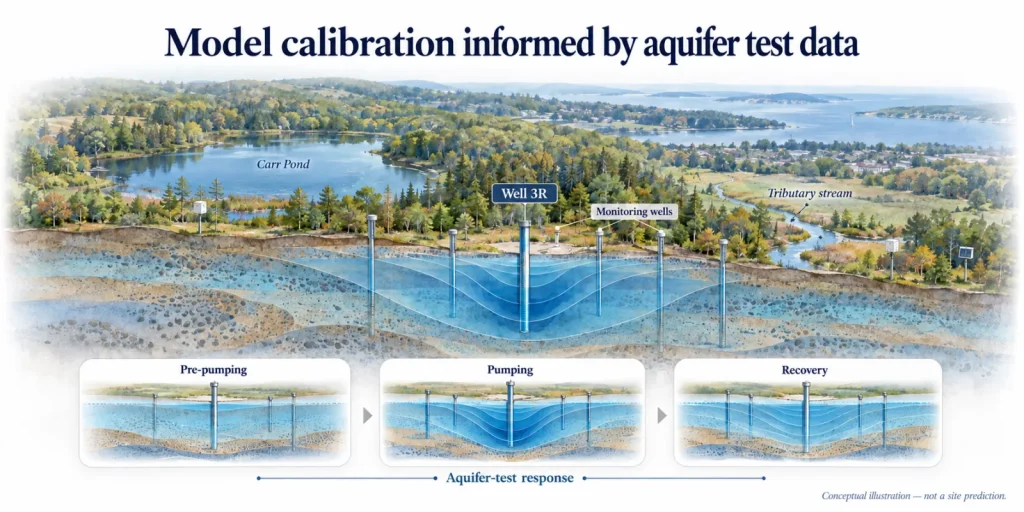
McDonald Morrissey Associates (MMA) developed a transient MODFLOW 6 modeling framework to evaluate a proposed replacement production well in the Hunt-Annaquatucket-Pettaquamscutt (HAP) River basin region. The work combined regional and local modeling, a Soil Water Balance (SWB) recharge model, aquifer-test observations, and PEST calibration to assess pumping capacity, drawdown, streamflow effects, and potential interactions with brackish surface water.
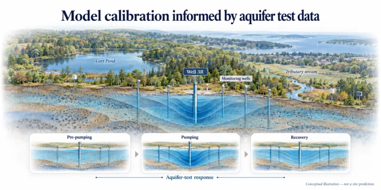
North Kingstown Water District’s existing Well Center 4 includes Wells 3, 7, and 8 with a combined permitted withdrawal of 800 gallons per minute. The proposed Well 3R would consolidate those withdrawals at one higher-yielding location near Carr Pond, an unnamed tributary, and the Pettaquamscutt River. Because the aquifer extends toward brackish surface water, the assessment needed to consider both pumping-induced drawdown and the sources of water captured by the new well.
Coupled regional and local models. MMA updated the regional HAP Basin model and linked it to a refined child model around Carr Pond, the supply wells, and nearby streams. MODFLOW 6 exchanges groundwater flow across the shared boundary, reducing reliance on assumed local boundary conditions.
Recharge grounded in local climate and land conditions. A site-specific SWB model used daily precipitation and temperature, mapped soils, land use, and topography to estimate spatially and temporally varying recharge and groundwater evapotranspiration.
Transient calibration to the aquifer test. The model represented pre-pumping conditions, Well 3R pumping at 1,276 and 1,144 gallons per minute, and post-pumping recovery. PEST adjusted 265 parameters using groundwater levels, domestic wells, streamflows, Carr Pond stages, and prior regional targets.
Predictive scenarios. MMA compared current distributed pumping with focused pumping at Well 3R under drought and average recharge conditions, while using automatic flow reduction to represent limits imposed by declining saturated thickness.
The calibrated model reproduced steady-state and transient groundwater heads with mean absolute error relative to target range below 1.5% for the principal head groups. Under the modeled average-recharge scenario, Well 3R could sustain approximately 980 gallons per minute after automatic flow reduction, compared with the existing 800 gallons per minute total permitted rate. The model also indicates that the additional pumping would be supplied primarily by reduced groundwater discharge to gaining streams, with increased inflow from Carr Pond, the regional model domain, and groundwater storage.
Though the simulations did not predict induced brackish-water seepage from the Upper Pond, MMA recommended monitoring and contingency planning, including additional wells between Well 3R and the Upper Pond, Carr Pond stage monitoring, and stream-discharge measurements.
This summary is based on a March 13, 2026 technical memorandum. Predictive results are scenario-based and should be interpreted with the stated data and uncertainty limitations.
Client
Arlington Land Trust (ALT)
Location
Arlington, Massachusetts
Documented involvement
2024–2026
Thorndike Place Residential Development | Arlington, Massachusetts
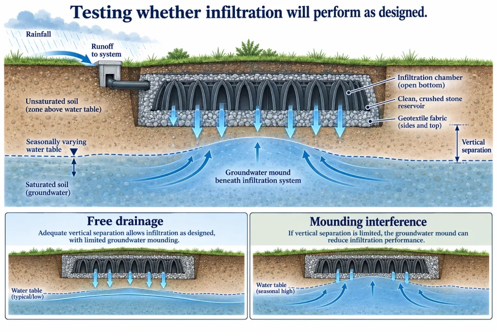
MMA provided a groundwater-hydrology review related to a proposed residential development on approximately 17.7 acres of forested, undeveloped land between Dorothy Road and Route 2 in Arlington, Massachusetts. The proposed project includes six duplex townhouse buildings, a four-story 126-unit apartment building, internal roads and parking, utilities, grading, and subsurface stormwater-infiltration systems. The review examined whether the available site data and analyses adequately represented seasonal groundwater conditions and the performance of the proposed infiltration design.
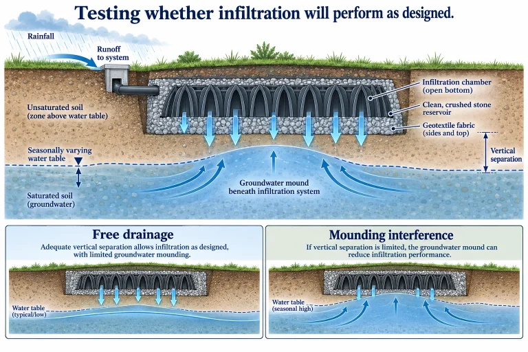
MMA evaluated infiltration-system configuration, seasonal high groundwater interpretation, vertical separation, design-storm recharge, groundwater mounding, and the relationship between mounding and the ability of systems to drain and perform as intended.
The work translated complex groundwater behavior into a clear technical record for regulatory and public review. It connected field measurements, regional hydrograph information, site design, and analytical calculations so that the proposed infiltration systems could be evaluated under the conditions that control real-world performance. The resulting testimony and exhibits supported a focused assessment of compliance with Massachusetts Stormwater Standards 2 and 3 and identified where design assumptions required closer scrutiny.
Project history reflects the supplied record through October 2026; no final appeal disposition is represented.
Tell us about your project. MMA can support your team with numerical modeling, technical review, and expert testimony.